Projects 7 - ISCouncil

WESTERN HARBOUR TUNNEL – PACKAGE 2

The WHT is a major transport infrastructure project that will make it easier, faster and safer to get around Sydney. By creating a western bypass of the Sydney CBD, the WHT will take pressure off the Sydney Harbour Bridge, Sydney Harbour Tunnel, Anzac Bridge and Western Distributor corridors to improve transport capacity in and around Sydney Harbour. The Western Harbour Tunnel is being delivered in two stages. The northern section of the tunnel, Stage 2, will be delivered by Acciona Construction Australia. This stage of the Western Harbour Tunnel sees early work construction expected to start in 2023. Stage 2 includes connections from Stage 1 at Cove Street, Birchgrove, to the Warringah Freeway near North Sydney, and complete tunnel fit-out.

The tunnel project will be built using two Tunnel Boring Machines (TBMs) to tunnel through clean sandstone under Sydney Harbour, while roadheaders will excavate the clean sandstone on the north side of the Harbour. Using the TBMs will eliminate any dredging activities through the Sydney Harbour seabed, removing risks to the marine environment and biodiversity and the need for construction sites at Yurulbin Point and Berrys Bay, significantly reducing construction impacts for thousands of residents in Birchgrove and Waverton. Once all excavation activities are finished, the roadheaders will be removed from the two northern tunnelling construction sites and the TBMs will be disassembled and removed in pieces. The larger parts of the TBMs that cannot be removed will be buried underground allowing for the mechanical and electrical (M&E) work to fit out the tunnels with lighting, safety features, and jet fans to proceed.

Sydney Metro West – Eastern Tunnelling Package

The Sydney Metro West, Eastern Tunnelling Package (ETP) involves the delivery of:
 Enabling works such as demolition, utility supply to construction sites, utility adjustments and modifications to the existing transport network
 Mined crossover cavern construction east of The Bays Station
 4.2km of TBM Tunnel excavation, 650m of mined tunnels and 7 cross passage excavation, from The Bays to Sydney CBD
 Excavation for two new underground metro stations at Pyrmont and Hunter Street
 Construction of a turnback, crossover tunnels and caverns at the eastern end of the tunnel section
 A concrete segment facility for use during construction located at Eastern Creek.

Longwarry WRP

Augmentation of the Longwarry Water Recycling Plant to meet significant predicted growth within railway corridor catchment area. South East Water believes there is significant opportunity to design and build a low emissions treatment facility that explore opportunities associated with circular economy initiatives for the local community, whilst improving effluent discharge quality and minimising risk to the environment.

Djarindjin-Lombadina Water Treatment Upgrade Project

Under the Essential and Municipal Services Upgrade Program (EMSUP), a Western Australian Government initiative, the Water Corporation has been funded to regularise and assume responsibility for operation and maintenance of water and wastewater assets across a number of Aboriginal Communities. Djarindjin and Lombadina are two of the communities that will receive upgrades under the EMSUP. Djarindjin and Lombadina are two adjacent communities located 170 km North-East of Broome on the Dampier Peninsula. These communities are currently being serviced by the Department of Communities and Housing (DoC).

Keon Parade Level Crossing Removal Project

The Project will remove the current Keon Parade level crossing by building a rail bridge over the road and building a brand-new Keon Park Station with modern facilities for passengers.

Elevating the rail line over Keon Parade will improve safety and reduce congestion for more than 18,000 vehicles travelling through the level crossing each weekday, with boom gates down for up to 41 minutes of the morning peak.

The architecturally designed, modern Keon Park Station will be built on the south side of Keon Parade and will benefit passengers and the local community through improved connections to local neighbourhoods, JC Donath Reserve, buses, local shops, cafés, and eateries.

The new station will have two entrances for convenient access, a central elevated island platform accessible via lifts and stairs, and two car parks on High Street and Keon Parade.

Parramatta Light Rail Stage 1 Infrastructure Works – As-Built

Certified Score: 104 (v1.2 As-Built)

Description:

Parramatta Light Rail is one of the NSW Government’s major infrastructure projects being delivered to serve a growing Sydney. Parramatta Light Rail Stage 1 will connect Westmead to Carlingford via the Parramatta Central Business District (CBD) and Camellia. The project will create new communities, connect great places and help both local residents and visitors move around and explore what the region has to offer. The route will link Parramatta’s CBD and train station to a number of key locations, including the Westmead Health Precinct, Cumberland Precinct, CommBank Stadium, the Camellia Town Centre, the new science, technology and innovation museum Powerhouse Parramatta, the private and social housing redevelopment at Telopea, the Rosehill Gardens Racecourse and three Western Sydney University campuses. The Infrastructure Works is being delivered by Parramatta Connect, a CPB Contractors and Downer Joint Venture, and includes the design and construction of civil works, public domain and light rail infrastructure up to road level/top of rail and to the top of the concrete slab at stops, including provision of utility services (excluding high-voltage power supply and cabling for rail systems), and decommissioning of the T6 Carlingford Line.

Key Achievements:

The project has achieved outstanding outcomes through:

  • Implementation of robust management and procurement systems that incorporate sustainable processes
  • Thorough assessment of climate change risks and implementation of climate change adaptation measures
  • Integration of significant energy, water and material reductions throughout the project’s lifecycle
  • Excellent environmental management of emissions, pollution, waste and ecology
  • Exceptional heritage management and monitoring ensuring heritage values are enhanced and leave a permanent legacy within the local community
  • Delivery of meaningful stakeholder engagement with creative and innovative solutions
  • Integration of best practice urban design principles into local areas
  • Australian and State First Innovative solutions integrated throughout the design and construction of the project
  • Workforce Development and Social Procurement Strategy which has achieved greater workforce diversity, upskilling of workers, engagement with social enterprises and aboriginal businesses, and provided opportunities for local communities.

Highlights:

The project has achieved an energy impact reduction of 33.8% with key initiatives such as the use of dimmer functions on LED luminaires; a water use reduction of 22% using a subsoil drip irrigation system with soil moisture sensors and a 28% material use reduction through re-use of heavy rail elements, MSF in concrete and recycled materials in concrete, asphalt, and aggregates. The cumulative impact of all the initiatives has achieved a carbon dioxide output reduction of over 76,000 tonnes.

The project’s robust management and governance systems have integrated exceptional sustainability processes leading to the achievement of full points in:

  • 5 of 7 management credits
  • all procurement credits and
  • both climate change credits.

‘People and Place’ elements have been a key focus for the project due to its location within the highly dense urban and rich heritage environment of Parramatta, Sydney’s second CBD. Parramatta’s rich and varied history of Aboriginal and European significance has been respected in bespoke designs, developed in consultation with Heritage NSW, such as using a wire-free design for much of the alignment, thin resin-bound footpath pavements to avoid disturbing unmarked graves, avoiding unnecessary removal of heritage bridge abutments, lighting solutions to minimise visual clutter, and salvage/reuse of sandstone and bricks. Heritage interpretation included paving inlays, interpretive signage, landscaping and installation of an indigenous garden. The project has produced a high-quality urban realm finish that is sympathetic to the heritage and cultural fabric of the three distinct precincts.

Acknowledgements:

Australian First

An Australian First innovation has been achieved using a bespoke light rail boot within the light rail trackform designed by Trelleborg for 51R1 rail. The use of the light rail boot on the project provides a complete warranted system for rail resistivity, stray current and meets the high noise and vibration attenuation requirements needed for the surrounding urban environment. The light rail boot has a double-wide top, an innovation unique to the project within Australia, which prevents rail wear, allows for reduced maintenance issues across the life of the light rail system and minimises repair works or replacement.

State First

The Parramatta Light Rail will be the first light rail system within NSW to use Macro Synthetic Fibres (MSF) within concrete for the trackform. The use of MSF reduces the quantity of steel reinforcement required and increases concrete durability and performance, enabling efficient construction and mitigation of potential stray current issues.

State First

The Parramatta Light Rail will be the first light rail system within NSW to implement green track. The green track constitutes 10% of the alignment and will integrate the light rail alignment within the public domain contributing to noise reduction, urban cooling, and material reductions, leaving a lasting positive impact on significant and sensitive existing urban spaces.

The achievement of the Leading As-Built Rating has been the result of multiple stakeholders’ input including:

  • Transport for NSW (TfNSW)
  • The Design Consortium (WSP & Aurecon)
  • The wider CPB Contractors and Downer EDI network


Testimonial: 

The achievement of a Leading ISC As-Built Rating reflects the hard work carried out by the entire Parramatta Connect project team, along with Transport for NSW, to deliver social, economic, and environmental initiatives throughout the project lifecycle. The rating achieved provides validation of our commitment to sustainable infrastructure and a third-party assurance review of our sustainability performance.

More Trains More Services Stage 2 South

About

Transport for Tomorrow is delivering service improvements on the T4 Illawarra Line, South Coast Line and T8 Airport Line as part of the Transport for New South Wales developed More Trains, More Services (MTMS) program.

The improvements would deliver greater capacity, reliability and connectivity for customers and are designed to support changes to the use of the stations and stabling yards to better serve the future operation of the T4 Illawarra and South Coast lines.

The current program of works upgrades rail infrastructure at the following locations:

  • Mortdale Maintenance Centre Upgrade
  • Waterfall Stabling Yard and Platform Extension Project
  • Wollongong Stabling Yard and Platform Extension Project
  • Long New Intercity Fleet Upgrade (Thirroul, Coniston, Bellambi & Kiama)
  • Port Kembla Southern Stabling Yards and Station upgrade
  • Kingsgrove Turnout Removal
  • Service Upgrades at Albion Park and Kembla Grange
  • Platform Extension and Station Upgrades at Dapto
  • Platform Extension at Shellharbour Junction
  • Kiama Stabling Yard and Platform Extension
  • Turnback Upgrades (North Wollongong, South Wollongong, Thirroul)

Within the MTMS2 South package, TfT will be delivering a Power Upgrades South scope consisting of

  • New Overhead Wiring Structures (7 new portal structures and 5 back guy foundations)
  • Replacement of Bridge Screens on the Bridge ST over-bridge
  • The introduction of an additional Catenary wire into the existing Overhead Wiring system (1.2 km)
  • Earthing and Bonding as required to support the upgrade
  • The installation of an “Auxiliary Wire” attached to each mast and running the length of the existing wire run (800m)

Linkfield Road Interchange

About

The Linkfield Road Interchange is located in the northern suburbs of Brisbane within the Brisbane City Council Local Government Area. Linkfield Road Interchange is the southern most interchange located on Gympie Arterial Road (M3), with Strathpine Road Interchange (and the Bruce Highway) located to its north. Linkfield Road provides an important east-west arterial route for freight, general traffic and commercial road users. Linkfield Road is classified as a Local Road of Regional Significance (LRRS) and is key in connecting the Brendale industrial precinct to the Australia Trade Coast, Brisbane Airport, the Port of Brisbane and the rest of South East Queensland via the M1 Gateway Motorway and the Bruce Highway. The current Linkfield Road overpass structure over Gympie Arterial Road is a two lane (one-lane each way) bridge with narrow shoulders and a low vertical clearance of 4.7m. To the immediate west and east of the interchange, is a 4-way at grade signalised intersection with Gympie Road and a 4-way at grade signalised intersection with Lacey Road, respectively.

The Australian and Queensland Governments are committed to manage the design and construction of the Linkfield Road overpass upgrade to align with stakeholder expectations, including reducing the project’s environmental footprint and building an increased network resilience to climate change. Sustainable outcomes proposed will go towards demonstrating the project’s commitment to contribute to net positive benefits for society and the environment will be the focus of the project during design and construction. The project will pursue the achievement of an Infrastructure Sustainability Council rating of ‘Excellent’ across both design and construction.

Upper South Creek Advanced Water Recycling Centre

Sydney Water is developing a modern, sustainable, and highly automated AWRC and circular economy hub in Kemps Creek in Western Sydney. Located at the junction of Kemps Creek and South Creek, the Upper South Creek AWRC will produce advanced quality recycled water suitable for release to the Nepean River in line with the Hawkesbury-Nepean nutrient removal framework. The AWRC Foundation Plant will treat wastewater and produce high-quality water (close to drinking water standard) with flexibility to supply recycled water to future local customers, including residential, commercial and agriculture users in the Western Sydney Aerotropolis Growth Area (WSAGA) and South West Growth Area (SWGA).

TAP3 Birrong Station, Wollstonecraft Station, Roseville Station, Banksia Station and Canley Vale Station

Project Description

The project is part of the NSW Government’s the Transport Access Program, which aims to provide a better experience for public transport customers by delivering accessible, modern, secure and integrated transport infrastructure.

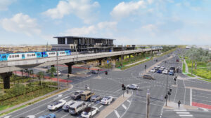
Under the TAP program, five train stations were upgraded to provide accessible access to people with a disability, limited mobility, parents/carers with prams and customers with baggage. Birrong, Wollstonecraft, Roseville, Banksia and Canley Vale Stations were included under an IS Council rating for Design and As Built v1.2.

The project achieved a Leading Design rating with a score of 91.63 and showcases best-practice design.

Key Achievements

These TAP Station upgrade projects leave a legacy of sustainable, community-centred, infrastructure, advancing the NSW government’s commitment to a low-carbon future by setting a new benchmark for future accessibility projects in TAP and other transport infrastructure projects.

Key project achievements include:

  • Rich interpretation of the heritage and diverse cultures of the places we work including extensive celebration of Aboriginal heritage and Country through positive stakeholder collaboration.
  • Predicted 30 per cent reduction of emissions associated with materials; a saving of 3,578 tonnes of carbon dioxide equivalent (t CO­­2-e).
  • Potential 34 per cent reduction in water consumption.
  • Predicted 34 per cent reduction of GHG emissions from energy use; a saving of 3,644 t CO­­2 -e.
  • Use of Building Information Management (BIM) 3D modelling to influence sustainable design decision making, tailored online and live procurement system to promote sustainable procurement initiatives and significant bush regeneration efforts in park land within and adjacent to our sites.

Project Highlights

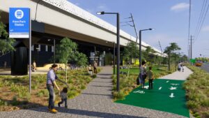
Highlight 1 – Saving resources

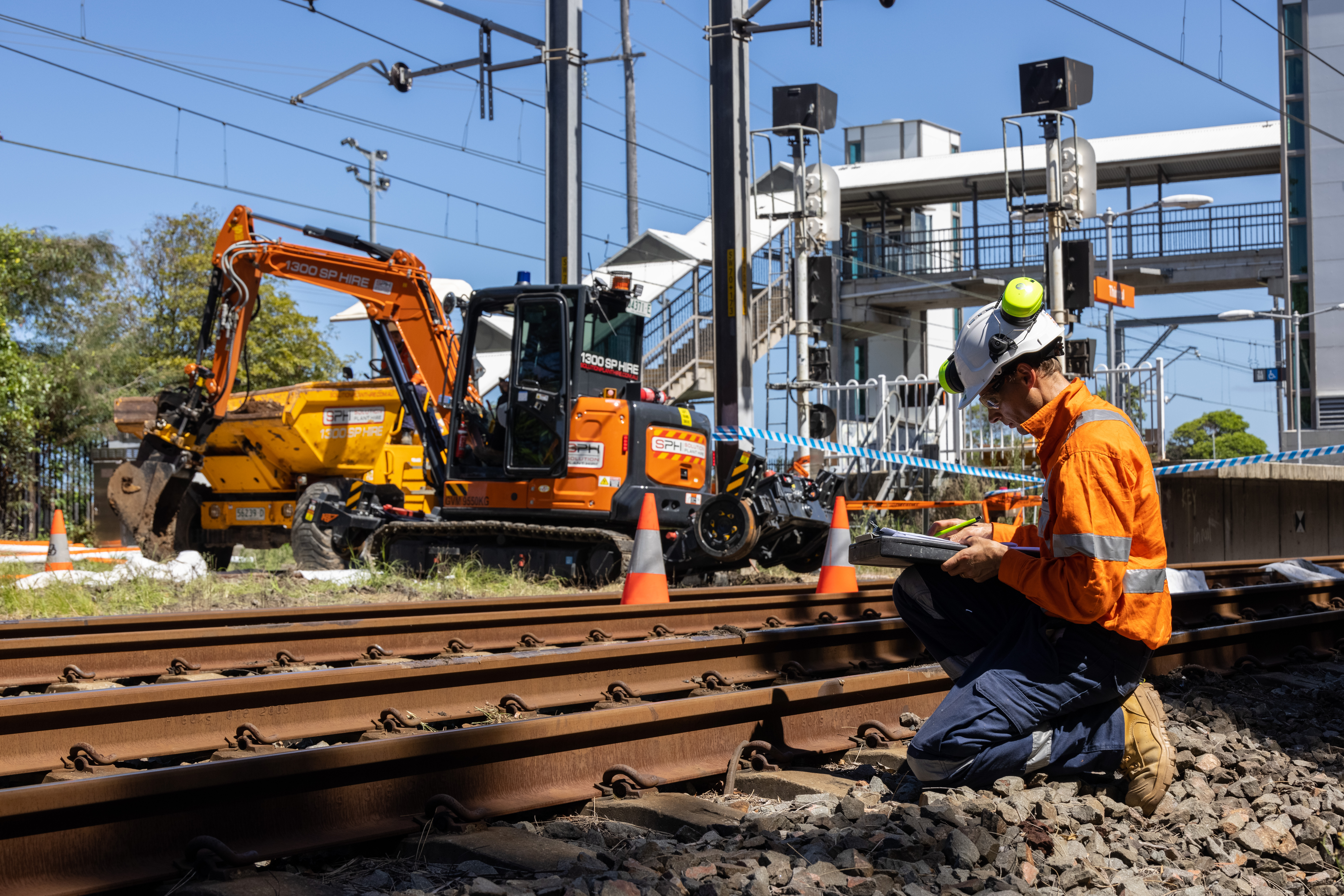
Each of the projects underwent various multidisciplinary workshops to optimise the resource-use profile (e.g. materials, water and energy) that would be needed to achieve compliance with the planning approval requirements without sacrificing the high standards of accessibility and service for the stations. Some of the key initiatives that were implemented are summarised below.

Energy and Carbon

Key initiatives for potential reductions in energy and carbon include:

  • Value engineering to reduce the number of lifts required with focus to achieve compliance with the Disability Standards for Accessible Public Transport and significantly reduce the predicted operational electricity demand
  • Construction electricity offset with GreenPower
  • Installation of motion sensors on lighting and exclusive use of LEDs
  • Procurement of Heating, Ventilation and Air-Conditioning with the highest energy efficiency ratio available on the market
  • Installation of Domestic Hot Water energy consumption reduction via water demand reduction and use of Instantaneous Hot Water units where possible
  • Supply of Energy Efficient lifts with low stand-by power

Potential achievement: 34 per cent reduction of greenhouse gas (GHG) emissions from energy use; the equivalent of 3,644 tonnes of CO­2-e. Of this predicted percentage for lifecycle reduction of GHG emissions, 53 per cent of GHG emissions reductions forecast during construction phase, and 33per cent of GHG emissions reductions forecast during operations phase.

Water

Key initiatives for potential reductions in water consumption include:

  • Passive pavement irrigation for planting/vegetation
  • Gravity fed “rip rap” drainage systems to support filtration and irrigation of surface waters to minimise mains fed water Irrigation
  • Landscape design focused on the use of drought resistant, low-maintenance native plantings as well as use of “water wells” for tree planting that increase the efficiency of water delivery.
  • Installation of high WELS rating appliances including:
    • 6 Star-rated toilets
    • 4+ Star-rated taps

Potential achievement: 34% reduction in water consumption across the project lifecycles and equivalent of 37 ML saved

Materials

Key initiatives for potential reductions in embodied carbon within materials included:

  • Implementation of BIM 3D modelling to identify significant sustainable design solutions to reduce material quantities. This included redesign of 50m span bridge at Birrong station to a single lift landing, providing equal amenity and accessibility whilst reducing bulk material quantities by 30%. At both Banksia and Roseville stations full bridge redesign was achieved through the retention and upgrade of existing assets. The design achievements with a “minimalistic” approach allowed for maintained amenity and accessibility of the stations and estimated saving of a combined 815 tonnes CO2-e alone in avoided materials use.
  • Project mandate of minimum of 40per cent cement replacement with SCM within all concrete.
  • Use of recycled aggregates, subgrades and ballast in replacement of virgin materials
  • 20 per cent Reclaimed Asphalt Product (RAP) within station asphalt scope
  • Minimisation of steel reinforcement within all low weightbearing footpaths
  • Implementation of numerous underline crossings (ULX) to minimise caballing routing and reduce cable quantities and lengths. and the replacement of galvanised steel troughing (GST) with recycled plastic “Tuftduct” troughing.

Potential achievement:  across all 5 stations a total 30 per cent reduction of embodied carbon in materials equating to a saving 3,578.7 tonnes CO2-e.


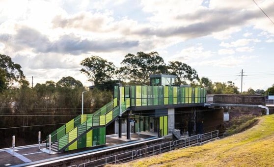
Birrong Station Upgrade


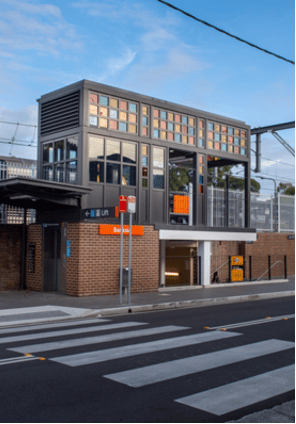
Banksia Station Upgrade


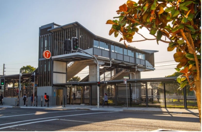
Canley Vale Station Upgrade

Highlight 2 – Heritage focus and rich interpretation of place

Aboriginal mural at Banksia

An opportunity was identified to go above and beyond project and contractual scope. Downer produced a large scale Aboriginal mural at Banksia Station. The Project team worked closely with TfNSW, Bayside Council and the Boomalli Aboriginal Artists Cooperative to organise a permanent installation. The painted mural allowed the legacy of the station to continue to be lived and enjoyed where there was previously no Acknowledgement of Country. Artist Danielle Mate designed and painted the 10m x 6m mural known as ‘Layers’ in early 2022 to speak to the Gweagal, Gadigal and Bidjigal clans who influence within the local area. The mural has received astounding positive feedback from the community and local press. The legacy will continue to influence for many years.


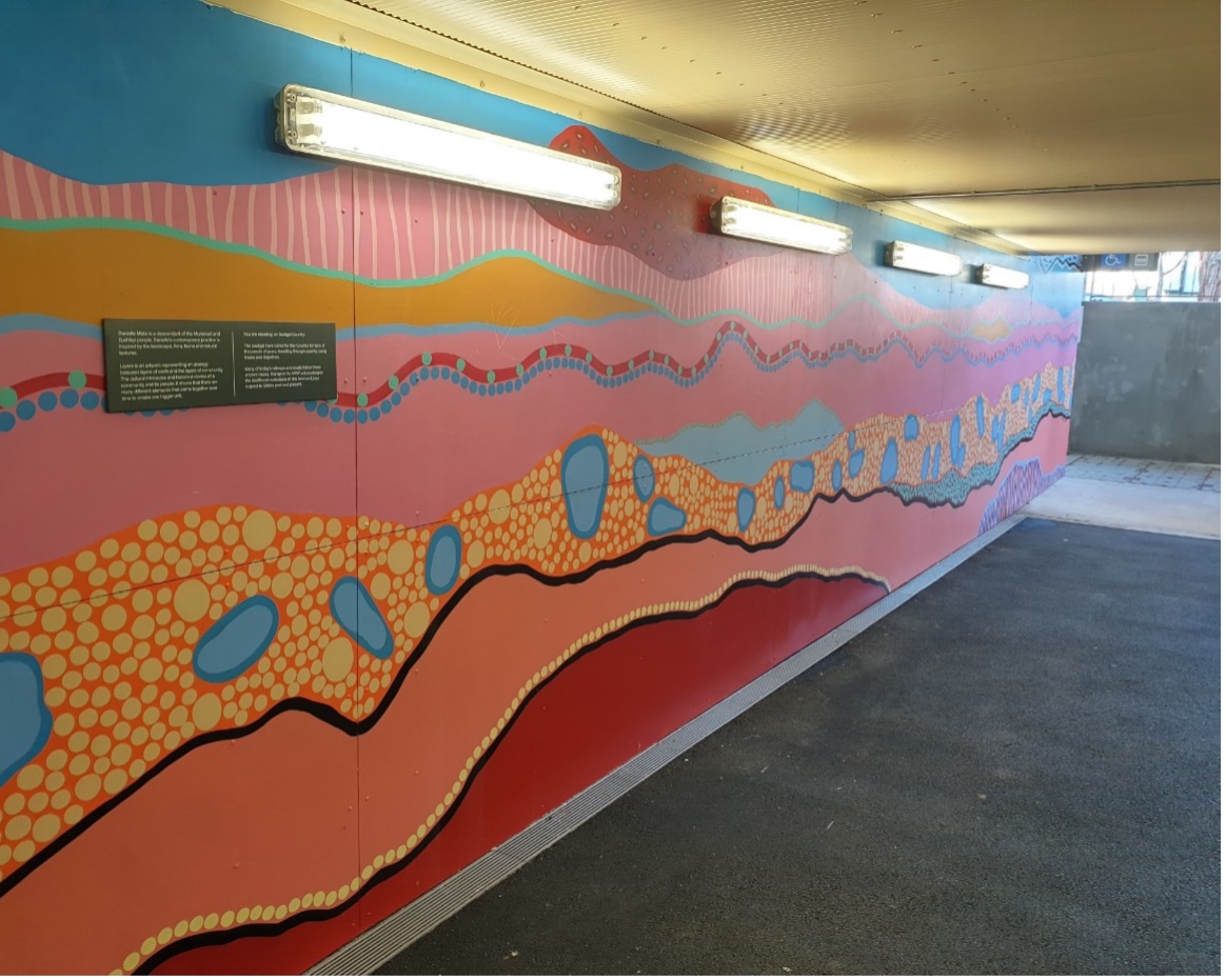
Aboriginal mural installed at Banksia Station

Banksia’ storms and station masters

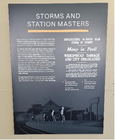
An interpretive sign installed in the Banksia underpass pays homage to the station’s long history of storms and station masters. Since the construction of the original underpass in the 1920s, it has been prone to flooding during heavy rainstorms.

Though Banksia Station’s history includes many flooding incidents, the actions of station staff over the decades have ensured the safety and dry feet of the community.

Now that the Upgrade Project is complete and intelligent flood mitigation implemented, flooding is no longer a problem for Banksia Station with zero closures or community delays even with the extreme floods and weather events that have been battering Sydney for months.


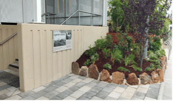
Interpretative sign installed at Banksia Station

Roseville heritage interpretation initiatives  

Several historical themes emerged for Roseville Station, including:

Landscaping and signage for the Garden Station – The Roseville Station gardens have been a source of community pride for over one hundred years. Landscaping and signs have been installed.


Roseville Interpretation landscaping and signs

Plaque installation for the Police Call Box – close to Roseville Station a small structure which today is used as bike shed was previously a Police Call Box. In a collaboration between Ku-Ring-Gai Council, TfNSW and Downer, the story of the shed was highlighted with a plaque.

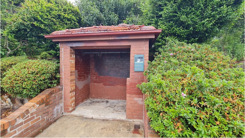
Roseville Police Call Box

Installation of acknowledgement of Gammeragal Country

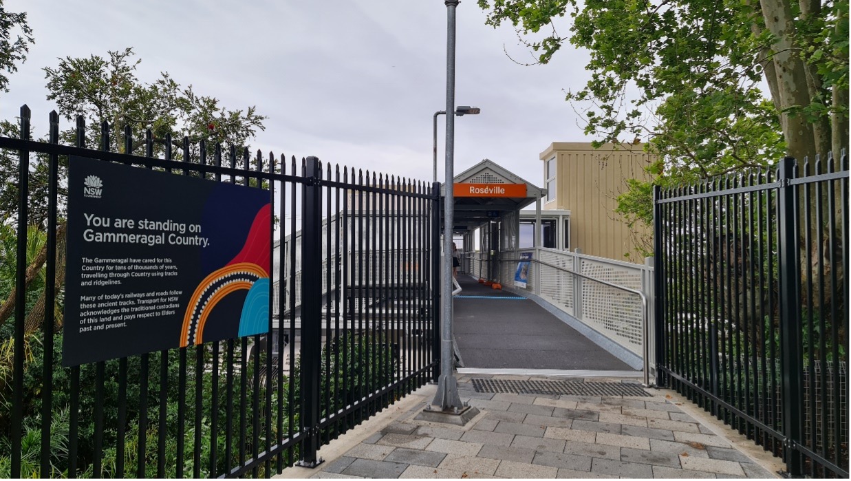
Acknowledgement of Gammeragal Country

IS Council Awards Finalist in ‘excellence in social outcomes’

In recognition of the social impact of the extensive heritage consideration and interpretation across the sites, the Project was confirmed as one of four finalists within the Infrastructure Sustainability Council Award for “Excellence in Social Outcomes” at the ISC ReConnect Conference in March 2022.

Highlight 3 – Bush regeneration within Smoothey Park

As part of the Wollstonecraft Station Upgrade Project, the project successfully reduced the number of trees removed during design development and creative engineering. Unfortunately, a few trees at the station still needed to be removed to allow the installation of the lifts and associated walkways.

The Project was required to replant 25 trees (or equivalent). An opportunity was identified to go above and beyond the project requirements and to work closely with North Sydney Council, as well as a locally owned and run bushland restoration company Toolijooa, to regenerate the natural bushland directly adjacent to the train station, Smoothey Park. Ultimately, about 400 plants have been installed as part of the works, including vital riparian restoration, weeding and planting of native locally endemic species.


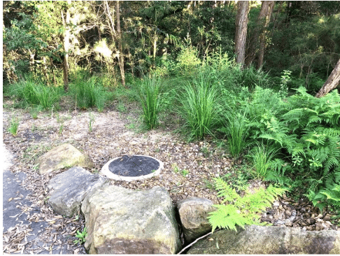
Section of revegetation and landscaping within Smoothey Park

Bruce Highway Dohles Rocks Road north facing ramps

The Bruce Highway is a major north-south transport route along Queensland’s east coast. The Bruce Highway serves an important role as the primary route for inter-regional general and freight traffic between Brisbane and Cairns. This national highway is progressively being upgraded under the Bruce Highway Upgrade Program (BHUP) which aims to improve safety, flood resilience and capacity along the Bruce Highway.

This project, Dohles Rocks Road Northern Connections (DNC), forms part of the BHUP and aims to provide a staged upgrade towards an ultimate whole-of-network solution for the Bruce Highway and its surrounding road network. The project consists of a stretch of the Bruce Highway from the Dohles Rocks Road interchange to Anzac Avenue interchange. It includes new north-facing ramps at Dohles Rocks Road interchange and the addition of fourth lanes onto each carriageway of the Bruce Highway.

DNC is part of a staged upgrade towards an ultimate whole-of-network solution for the Bruce Highway and the surrounding road network.