Projects 5 - ISCouncil

Monash Freeway Upgrade Stage 2 – As Built

Description:

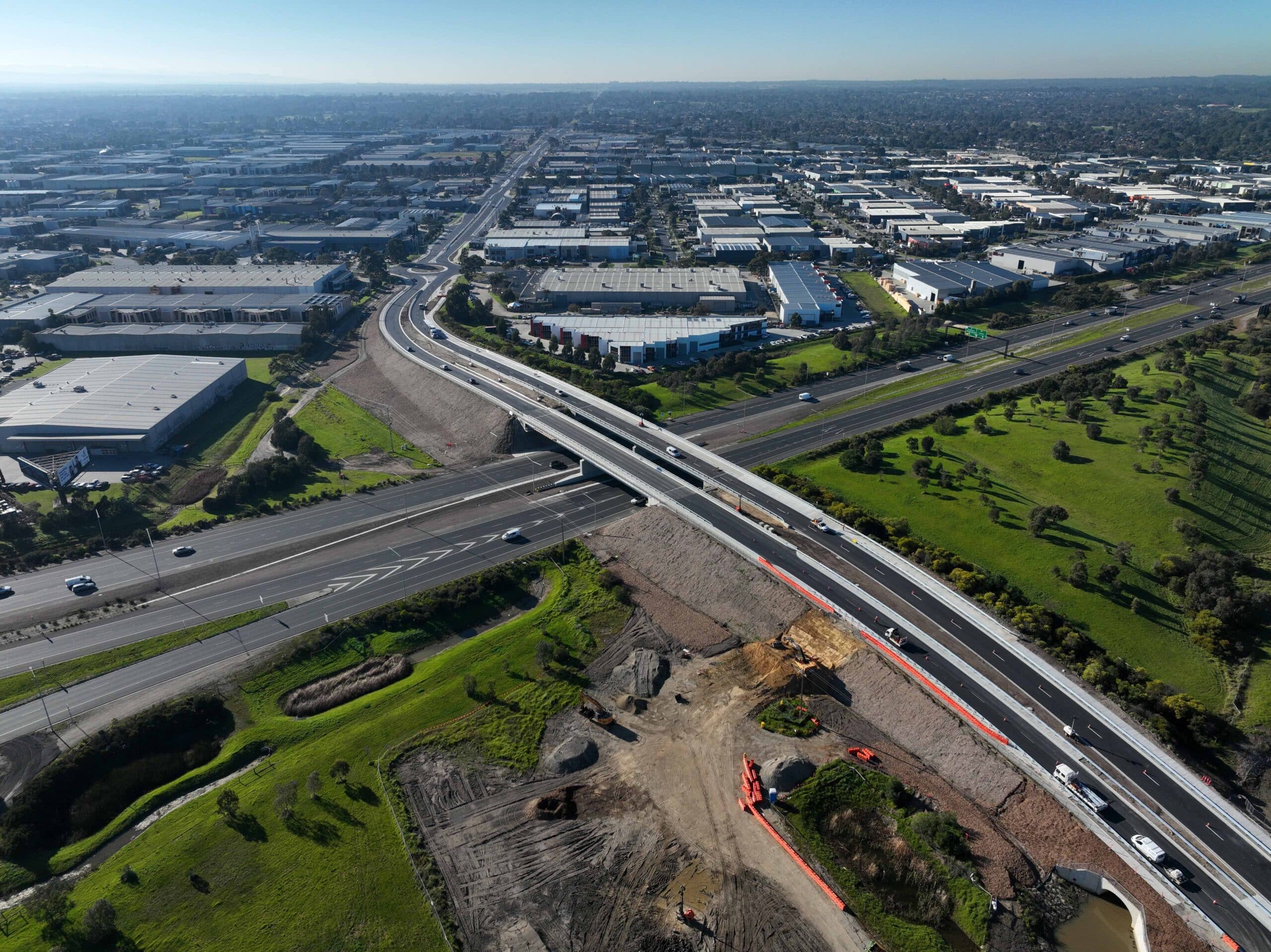
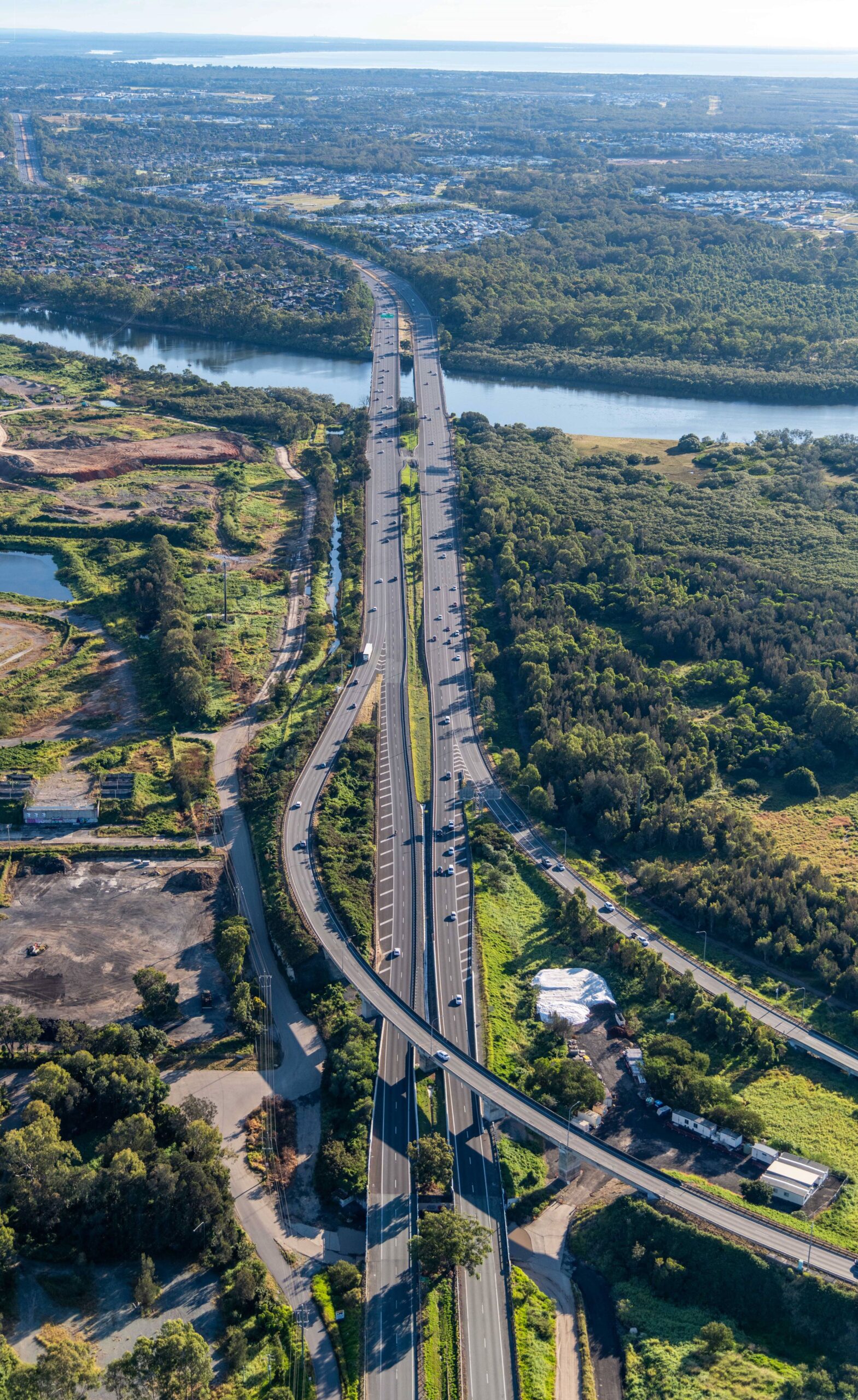
The Monash Freeway is in Melbourne’s fast growing south east and outer south east region, carrying over 470,000 trips per day. Works being undertaken by CPB for Stage 2 include the addition of 36 kms of new lanes on the Monash Freeway and Princes Freeways, between Warrigal Rd and EastLink outbound, EastLink to Springvale inbound and Clyde Rd to Cardinia Rd, in both directions.  

Project scope also includes: 

  • Connecting Police Road to the freeway with an outbound on-ramp  
  • Connecting the Jacksons Road outbound ramps directly to Eastlink with a separate road 
  • Adding two extra lanes in each direction on O’Shea Road between Clyde Road and Soldiers Road 
  • Upgrading the Beaconsfield Interchange – extending O’Shea Road so it joins the interchange, adding an inbound freeway off-ramp and an outbound freeway on-ramp 
  • Building shared walking and cycling paths on O’Shea Road between Clyde Road and the Beaconsfield Interchange. 

Rating Highlights 

Category  Credits  Achievements/Risks 
Management Systems  Man-6  The Project achieved a verified level of 3 with a score of 1.70. 

The Project utilised the following initiatives to highlight and encourage sustainability knowledge sharing within the organisation and across the industry: 

  • National Recycling Week 2020 campaign to share waste management knowledge.  
  • Conducting fortnightly, monthly, and quarterly Sustainability Opportunities and Initiatives forums within the organisation. 
  • Hosting Sustainability Operations Review Group and Sustainability Review Committee with key stakeholders. 
  • Establishing the Major Roads Interface Committee for Sustainability as a voluntary networking group to facilitate knowledge sharing with the broader industry.  
Ecology  Eco-1  The Project achieved a verified level of 3 with a score of 5.68. 

The Project has met and exceeded Habitat Compensation Obligations by securing the following offsets: 26.690ha for Southern Brown Bandicoot and 11.013ha for the Growling Grass Frog. The Project has also prioritised avoiding negative ecological value impacts during construction by establishing site-specific risk assessments and reducing native vegetation clearing within the project area.  

Stakeholder Participation  Sta-2  The Project achieved a verified level of 3 with a score of 1.42. 

The Project has demonstrated engagement with the “collaborate” level of the IAP2 Spectrum to update the local road design, future proof shopping centre access, extend the permanent noise wall and improve property privacy. The Project has also worked with stakeholders by identifying and communicating non-negotiable issues such as traffic access to a private hotel business.  


Verified Innovations 

Name   Verification Date  Project Publication sign off  Innovation Type   Description & Sustainability Benefits 
Hydro Demolition Water Recycling  26/10/23    Innovative Technology or Process 

Australian First 

The Project received 3 points for this innovation. 

Aqua Prep has been engaged to undertake hydro-demolition works and concrete cutting using water treatment and recycling technology that reuses 100% of non-potable water.  Without recycling, contaminated water would need to be carted offsite to be dealt with as per EPA Waste Regulations and the Hydro-Demo Truck would need to drawdown new potable water each day. Recycling in-situ eliminates both the need refill with potable water each day, as well as impacts associated with carting and processing contaminated water offsite.   

ISupply  26/10/23    Innovation Challenge (IC-8)  The Project received 0.75 points for engaging with the following suppliers and services on the ISupply directory: 

  • Bingo Industries: waste management  
  • SMEC Australia: Climate Change Risk Assessment  
  • Green Power Solutions: providing biodiesel generators 
  • Aurecon: detailed design  
  • ResourceCo Material Solutions: topsoil provision and spoil haulage  
  • Hanson Construction Materials: in situ concrete supply 
Humes Carbon Neutral Precast Concrete Barriers   26/10/23    Innovative Technology or Process 

Australian First (awarded under 12-month ruling)  

The Project received 3 points for this innovation. 

The Project has claimed an Australian First for the use of carbon-neutral concrete for infrastructure projects. As a result, the extensive use of pre-cast concrete barriers has contributed to the associated carbon emission reductions via Humes.    

GuardDog Drain Filter  26/10/23    Innovative Technology or Process 

Australian First 

The Project received 3 points for this innovation.  

The Project has claimed an Australian First for the use of the GuardDog Drain Filter. This low-profile and rapidly installed water filter has demonstrated better environmental control and maintenance and transport requirements compared to conventional methods. 


Lathams Road Upgrade Project – As Built

Project Description:

The Lathams Road Upgrade Project involved the duplication and widening of Lathams Road from two lanes to four lanes between Oliphant Way and Frankston-Dandenong Road, including a new bridge over the Mornington Peninsula Freeway and widening and tie-in to the EastLink entry and exit ramps to Oliphant Way. The length of carriageway upgraded is 2.5km.

Rating Highlights

Category Credit Achievements/ Description
Materials Over 180,000 tonnes of recycled content used in construction materials. 40% Portland Cement Reduction across all concrete mixes.
Energy Lifecycle carbon and energy reduction of 15.3% across the design life of the Project. 24% of construction energy replaced with renewables. Over 900 tCO2e reduced through sustainable construction practices.
Climate Change 100% of high rated and 82% of medium rated climate change risks addressed with adaptation measures throughout design and construction

Verified Innovations

Innovation Name: Polyrok

Description: Recycled soft plastic aggregate replacement in concrete

Acknowledgements – People

The Lathams Road Upgrade Project team gives special thanks to the below for their assistance and advice in assisting Winslow Infrastructure successfully deliver its first As Built rating under the ISC rating scheme.

Edge Impact – Emma Rolls, Gabriella Costa, David Maucor, Julia Rogerson

Perspektiv – Simon Hooper

MRPV Sustainable Infrastructure team – Rhys Owen-Roberts, Adam Mullins, Tracey Carey

ISC Project Managers – Luke Sammut and Giovanni Negroni

Alkimos Seawater Desalination Plant

A reduction in rainfall and an increase in population means Western Australia needs a new water source. The Alkimos Seawater Desalination Plant will be WA’s next major water source. At completion of stage 1 the plant will supply 50 billion litres of clean, safe drinking water to millions of Western Australians each year.

The desalination plant in Alkimos will include:

– A 50 billion litres per year desalination plant within the Alkimos Water Precinct
– An ocean intake pipeline below the seabed that brings seawater into the plant
– An ocean discharge pipeline below the seabed that safely takes brine (salty water) away from the plant
– Built-up, vegetated sand dunes on the western side of Alkimos Water Precinct. We will incorporate this into the existing natural dune system to minimise potential visual and noise impacts from the plant.

Bruce Highway (Gateway Motorway to Dohles Rocks Road)

Description

The Bruce Highway (Gateway Motorway to Dohles Rocks Road) project is part of integrated planning for the Gateway Motorway and Bruce Highway Upgrades in north Brisbane and the Moreton Bay Region. 

 Key features of Bruce Highway (Gateway Motorway to Dohles Rocks Road) include; 

  • upgrading the Bruce Highway and Gateway Motorway merge to provide a priority connection at a posted speed of 100km/h 
  • providing collector-distributor roads on both sides of the Bruce Highway to cross the Pine River through to Dohles Rocks Road, constructing new bridges over the Pine River  
  • installing a shared pedestrian and bicycle path adjacent to the highway, including across the Pine River. 

Cross River Rail – Tunnels and Stations


Cross River Rail is a new 10.2 kilometre rail line from Dutton Park to Bowen Hills, which includes 5.9 kilometres of twin tunnels under the Brisbane River  Hills, which includes 5.9 kilometres of twin tunnels under the Brisbane River and the CBD, and four new underground stations.

The Cross River Rail Tunnels & Stations package involves the design and construction of the underground section of the project under a public-private partnership by the Pulse consortium, with the design and construction joint venture comprising CPB Contractors, BAM International, Ghella and UGL.

The project commenced in mid 2019 and was awarded a Leading IS Design rating. Construction is scheduled to complete in 2024.

Details

Tunnels & Stations is delivering the underground section of the project under a public-private partnership by the Pulse consortium, with the design and construction joint venture comprising CPB Contractors, UGL, BAM International and Ghella.

The scope comprises

– The tunnel from a southern portal near Dutton Park station, under the Brisbane River and the CBD, to a northern portal beyond Normanby

– Four new underground stations at Boggo Road, Woolloongabba, Albert Street and Roma Street and upgrades to Dutton Park railway station.

– The tunnel portals and dive structures

– All associated mechanical, electrical and safety systems, including vertical transportation for passengers at underground stations

– Above and underground track work, traction power systems and selection rail operation and control infrastructure.

Rating Highlights

The project has to-date achieved a range of lower carbon concrete outcomes, was designed to maximise natural ventilation and natural light in station entrances which reduce lighting and the scope of air conditioning whilst ensuring patron comfort, and included a range of flood and climate change mitigations.

Website

For more information about this project, please visit www.crossriverrail.qld.gov.au

Inland Rail Illabo to Stockinbingal

Description

This 39km section of Inland Rail creates a new direct route from east of Illabo tracking north to Stockinbingal in New South Wales.

The route will bypass the townships of Cootamundra and Bethungra and the winding, steep section of track known as the Bethungra Spiral on the Main South line—opening up a more efficient way to transport freight through the area.


Inland Rail Albury to Illabo

Description

The Albury to Illabo section of Inland Rail includes enhancements along approximately 185km of existing rail corridor from the Victoria-NSW border to Illabo in regional New South Wales.  While we will use the existing rail line, we need to make enhancements and modifications to provide sufficient height and width to support the safe running of double-stacked freight trains. 

Works will include enhancements to: 

  • rail tracks 
  • footbridges and road bridges 
  • overhead structures 
  • signal structures 
  • level crossings 


NGCS Program – Merrimac Station Project

The New Merrimac Station is the third train station to be delivered under the Cross River Rail Delivery Authority. This will be located on Gooding Drive, approximately 750 metres east of the Pacific Motorway and Gooding Drive Interchange (Exit 77)

The Station will include:
• Two new 155m long side high-level platforms with 220m space allowance for future extension to accommodate a 9-car train.
• An overhead pedestrian footbridge connecting both sides of the station and platforms, including the provision of passenger lifts (DDA compliant – through lifts) from each side.
• Stair access to be provided to the pedestrian footbridge, for both access and egress from the site.
• Replacement of overhead electrical gantries throughout the new station.
• New station car parking facilities with DDA bays, taxi bays, kiss n ride bays, and bus stop and layover bays connected to Merrimac Station.
• A new signalised three-way intersection provided at the junction of Gooding Drive.

Trunk Main from Alkimos Seawater Desalination Plant to Wanneroo Reservoir

Stage 1 of the Alkimos Seawater Desalination Plant (ASDP) will deliver a plant capable of producing 50GL/a of water supply to Perth and Peel region, which in the future will have the potential to expand to 100GL/a (Stage 2). Together with the Eglinton Groundwater Scheme, also to be delivered by 2028 (4.9 GL/a), these two major water sources will produce an estimated combined capacity of ~105GL/a. Due to the location of the site in Alkimos, the seawater desalination plant will require a Trunk Main to deliver the source water to the closest Integrated Water Supply Scheme (IWSS) large storage facility in Wanneroo known as the Wanneroo Reservoir. To enable the integration of the new water source into the IWSS, it is proposed that a 32.5km Trunk Main (TM) is installed from ASDP to Wanneroo Reservoir with an offtake to Carabooda Tank. The first 6km of the 32.5km ASDP TM is commenced delivery in early 2022. This project is to deliver the remainder and majority of the 32.5km connection.

Waihoehoe Road

The Project proposes signalised intersections on Waihoehoe Road at Great South Road and Kath Henry Lane. The Waihoehoe Bridge over the North Island Main Trunk (NIMT) is proposed to be reconstructed offline to provide for the widened carriageway cross section including an active mode corridor and raised to allow sufficient space underneath for future rail upgrades (electrification and future rail tracks). To the west, the Project will tie into existing Norrie and Great South Roads, and to the east, the Project will tie into existing Waihoehoe Road at the Kath Henry Lane and Drury Central Station (DCS) access intersection. The functional intent for the upgrade, in line with the Project objectives, is to provide a strategic link that provides access to the planned Drury East housing development area and connects the DCS and associated park and ride facilities, forming a key public transport and active mode spine.

Boundary Road (Coopers Plains), rail level crossing upgrade

Boundary Road (Coopers Plains) rail level crossing project is being delivered by the TMR, and funded by the Australian Government (AG), Queensland Government (QG), and Brisbane City Council (BCC).

Boundary Road (Coopers Plains) is a BCC controlled road which connects to Beaudesert Road and acts as a key east-west link between Archerfield and the M1 Gateway Motorway. The primary objective of this project is to improve the safety and congestion of the existing road-rail level crossing on Boundary Road at Coopers Plains.

At the level crossing, Boundary Road (Coopers Plains) crosses the Beenleigh and Gold Coast Rail Lines, which consists of three tracks. The number of scheduled trains per 24-hour period is approximately 202 resulting in significant boom gate downtime during morning and afternoon peak periods.

The Boundary Road level crossing has consistently been named as one of Queensland’s top 10 worst level crossings from train drivers’ perspectives in TrackSafe’s 2013 survey and has been identified in multiple reports as a high-risk level crossing with recommendations for removal, including:
• 2012 Deloitte – Boundary Road in top six high risk priority crossings
• 2019 Queensland Rail ALCAM (Australian Level Crossing Assessment Model) – identified Boundary Road in the top 3 most dangerous crossings in Queensland
• 28 boom strikes (2009 – 2016) the third highest rate during this time period
• 101 incidents at the site (2004-2011

The project will remove the existing level crossing at Boundary Road by providing a new overpass over the rail corridor and provide an elevated three-way intersection connecting Boundary Road and Orange Grove Road.

Marinus Link Program

Marinus Link is a proposed electricity and telecommunications interconnector between Tasmania and Victoria. It will enable the flow of electricity in both directions between the two states, delivering low-cost, reliable and clean energy for customers in the National Electricity Market (NEM). It will enable excess energy generated on the mainland to be stored in Tasmania’s hydro storage, and made available for use when NEM demand outstrips supply.

The underground and undersea electricity and data cable will run 255km undersea from North West Tasmania to Waratah Bay in Victoria, then a further 90km underground to the Latrobe Valley. Converter stations at each end will be constructed and convert the electricity from direct current (DC) to alternating current (AC), for use in the states’ grids.
Marinus Link will have a 1500-megawatt (MW) capacity, equal to the power supply for 1.5 million Australian homes.
The project will be delivered in two stages. Construction of stage one is expected to start in early 2025.